4. Interface Zone: The Levantine Corridor as a Functional Hub
Between the two main civilizational poles lay a space that, for the purposes of this study, is regarded as an interface zone or a functional hub. It was neither an independent civilizational pole nor a periphery, but rather a conduit — the Levantine land bridge, which included the territory of historical Canaan, roughly corresponding to modern-day Israel and the Palestinian territories.
Unlike monolithic Egypt and polycentric Mesopotamia, Canaan during this period was characterized by a mosaic-like and segmented political structure. There was no unified state here. The region was divided into numerous city-states (Megiddo, Hazor, Shechem, Jerusalem, Lachish, and others), ruled by local rulers whom Akkadian documents refer to as khazanu. These cities were politically independent centers that constantly maneuvered between the influence of the southern and northern civilizational poles.
An additional factor contributing to instability was the groups known in the sources as the habiru (apiru). Modern scholars view them not as a single people, but as a broad social category of individuals who existed outside the established political and economic structures: fugitives, mercenaries, debtors, and other marginalized groups, who often participated in armed conflicts and raids.
Physical Infrastructure and Logistical Constraints
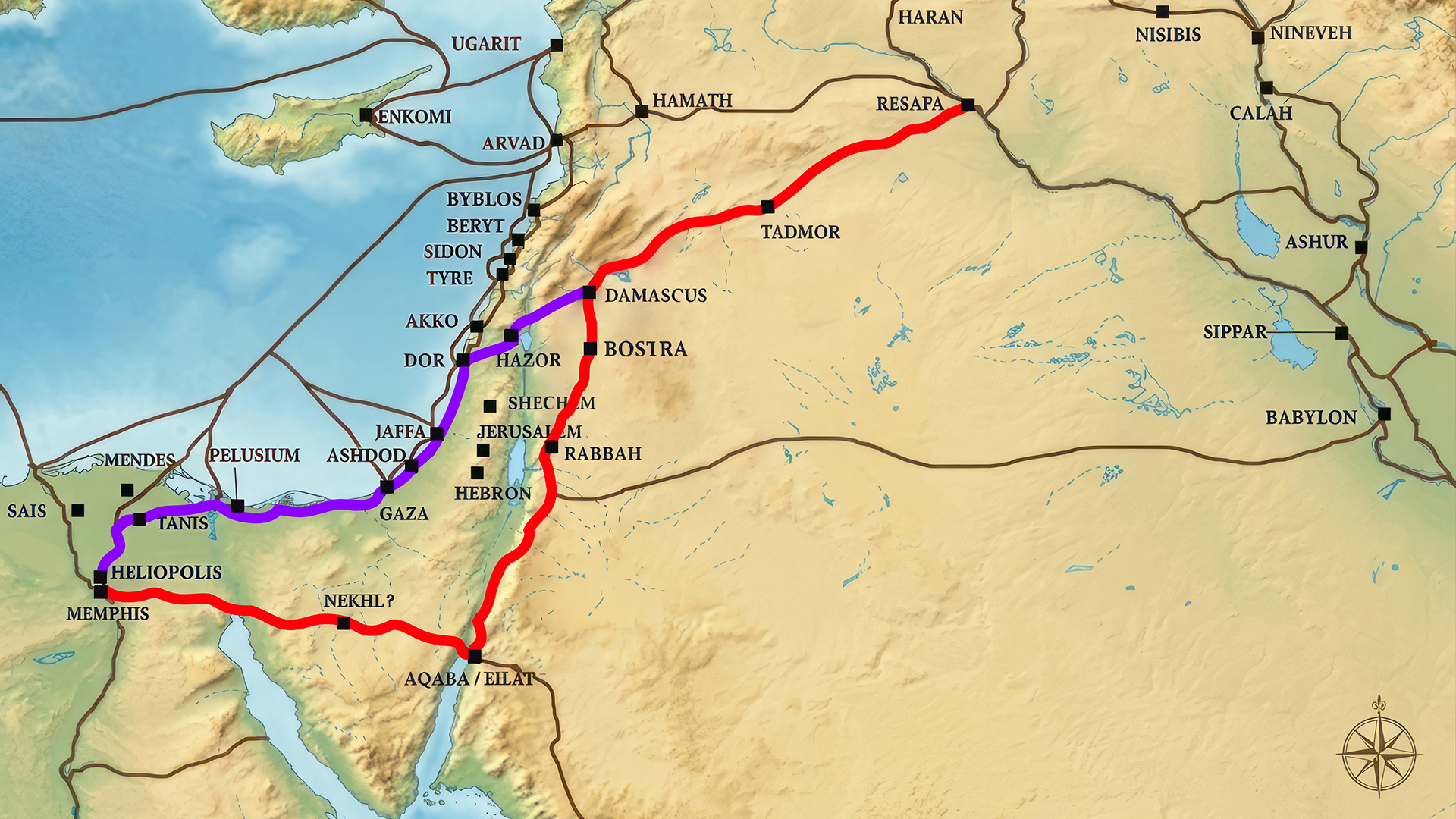
The Levant’s geographical location made it an inevitable transit corridor. The region is sandwiched between the Mediterranean Sea to the west and the Syrian Desert to the east. All traffic between Egypt and Mesopotamia was physically channeled through two main arteries:
Via Maris (the Coastal Road) — which ran along the coast and served as the main route for the movement of armies and large trade caravans.
Via Regia (the Royal Road) — ran further east, across the Transjordan Plateau, and was used for the transit of valuable goods (incense, spices) and as an alternative military route.
Illustration.
Approximate reconstruction. Via Maris (purple), Via Regia (red), and other ancient roads of the Levant, circa 1300 BCE.
Technical Audit of Insulation: Why Canaan, Specifically?
If we consider the geography of the Eastern Mediterranean and the Near East, there were vast expanses between Egypt and Mesopotamia that significantly limited the ability to move armies, goods, and administrative structures on a regular basis during the Bronze Age. Alternative routes did exist, but they were characterized by significantly greater logistical complexity and cost.
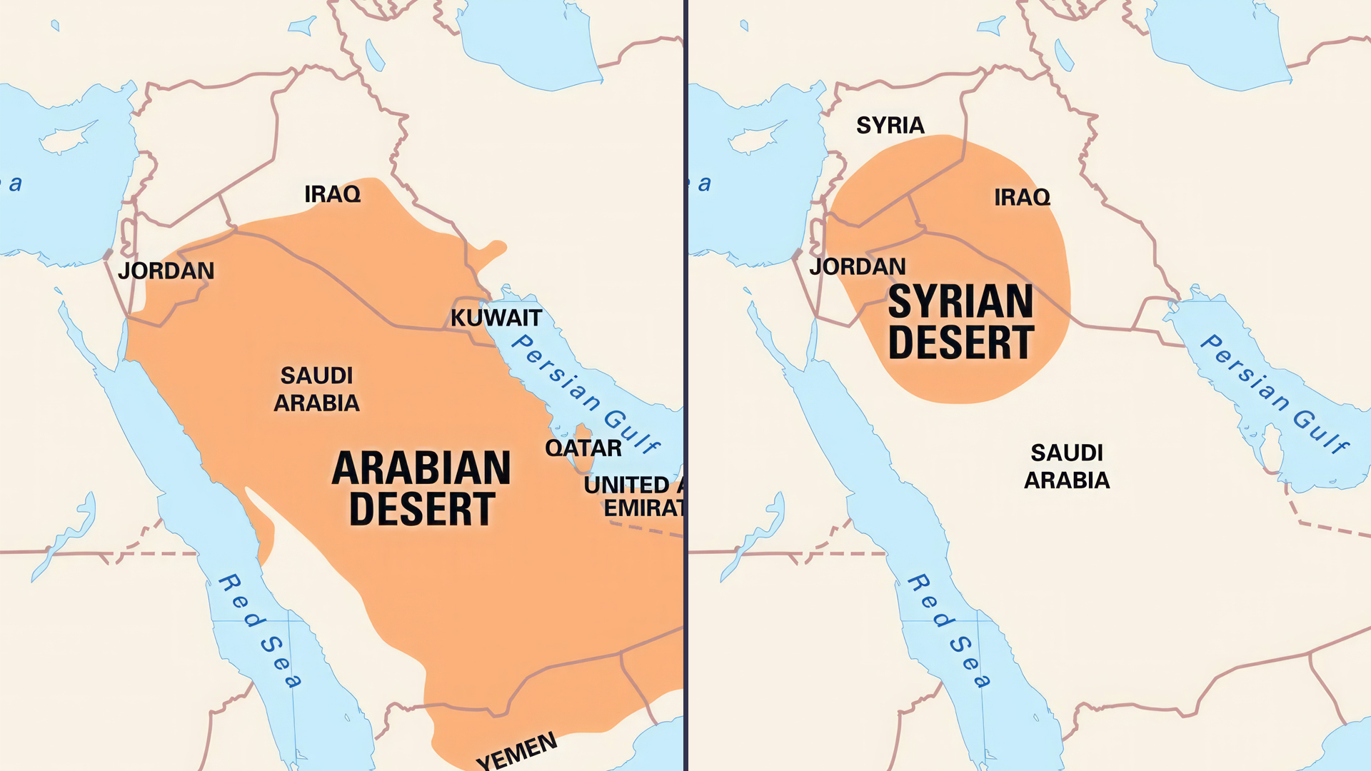
The Syrian-Arabian Desert (eastern edge) was a vast arid zone where, prior to the widespread domestication of the dromedary (late 2nd–early 1st millennium BCE), large-scale movements of caravans and military contingents were extremely difficult due to a lack of water and infrastructure. Nevertheless, individual trade routes and local crossings through the desert regions did exist.
Illustration.
The Syrian and Arabian deserts on a modern world map as they appear today. 1) Arabian Desert. 2) Syrian Desert.
During the Late Bronze Age, the Mediterranean Sea (western coast) was used primarily for coastal and island (coastal) shipping. Long-distance sea crossings were limited by the technical capabilities of shipbuilding and navigation; therefore, the transport of large land armies and heavy military systems by sea remained a rare and sporadic occurrence.
Thus, this was not a matter of the region’s complete isolation, but rather of significant disparities in transportation accessibility across different routes. Under these conditions, the Levantine Corridor retained the greatest functional efficiency as the main overland bridge between the two civilizational centers of the ancient world.
As a result, nature left only one viable route — the so-called Fertile Crescent. Canaan became its “bottleneck” — the only convenient corridor where water, fodder, relatively flat terrain, and the ability to rely on local urban infrastructure were all present simultaneously.
This is precisely why control over this corridor took on absolute geopolitical significance. Whoever controlled Canaan controlled the lifeblood of the two greatest civilizations of antiquity.
The Dynamics of Processes in the Hub Area
During the Late Bronze Age, three key processes were simultaneously at work in the Levant:
Buffering of conflicts. The Levant served as a space where military clashes between the region’s major powers were mediated, reducing the likelihood of their spreading deep into the territories of the main civilizational centers while simultaneously concentrating military activity in the contact zone.
Intensive cultural and technological synthesis. Diplomatic missions, trade caravans, military contingents, and technological innovations continuously passed through the Levant, creating a stable zone of high cultural and informational interaction between Egyptian, Mesopotamian, and local traditions.
The emergence of new writing systems. It was in this region, amid contact between cuneiform and hieroglyphic traditions, that early forms of Proto-Sinaitic and Proto-Hittite writing arose. These systems did not replace existing methods of recording information but expanded the range of possible graphic solutions and became an important stage in the development of the alphabetic principle of writing.
Thus, the Levantine Corridor served not only as a geographical bridge between two civilizational poles but also as an active functional hub through which political, military, and cultural flows passed, concentrated, and were redistributed; as a result, the region itself was simultaneously influenced by these processes and became a factor in their further intensification and transformation.